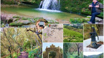
Road to the mythical "Do Morto" Trail (En-Es)🌄🧭🚩
6
About :
Helloo adventurers and drone lovers! I bring you a very special post and with the best views of the mountain range of Lousa, taking advantage of the fact that I can pilot my drone a maximum of 60 meters I wanted to give you my route from all angles, the path to the trail is demanding and now in winter it becomes quite slippery, but this is not about my adventure but about the history and mythology of the path that is customary to follow at sunset to walk among the souls of the adventurers who died there...🙇♂️🚶♀️🌏

20 kilometers of adventure🚩🧭
Holaa aventureros y amante de los drones! les traigo un post muy especial y con las mejores vistas de la sierra montañosa de Lousa, aprovechando que puedo pilotear mi drone un maximo de 60metros quise darles mi recorrido desde todos los angulos, el camino hacia el sendero es exigente y ahora en invierno se hace bastante resbaladizo, pero esto no se trata de mi aventura si no de la historia y mitologia que tiene el sendero que se acostumbra a realizar al atardecer para caminar entre las almas de los aventureros alli fallecidos...🚙🌄🍄

About the legend of the place🙇♂️🚩/ Sobre la leyenda del lugar🧭🌄


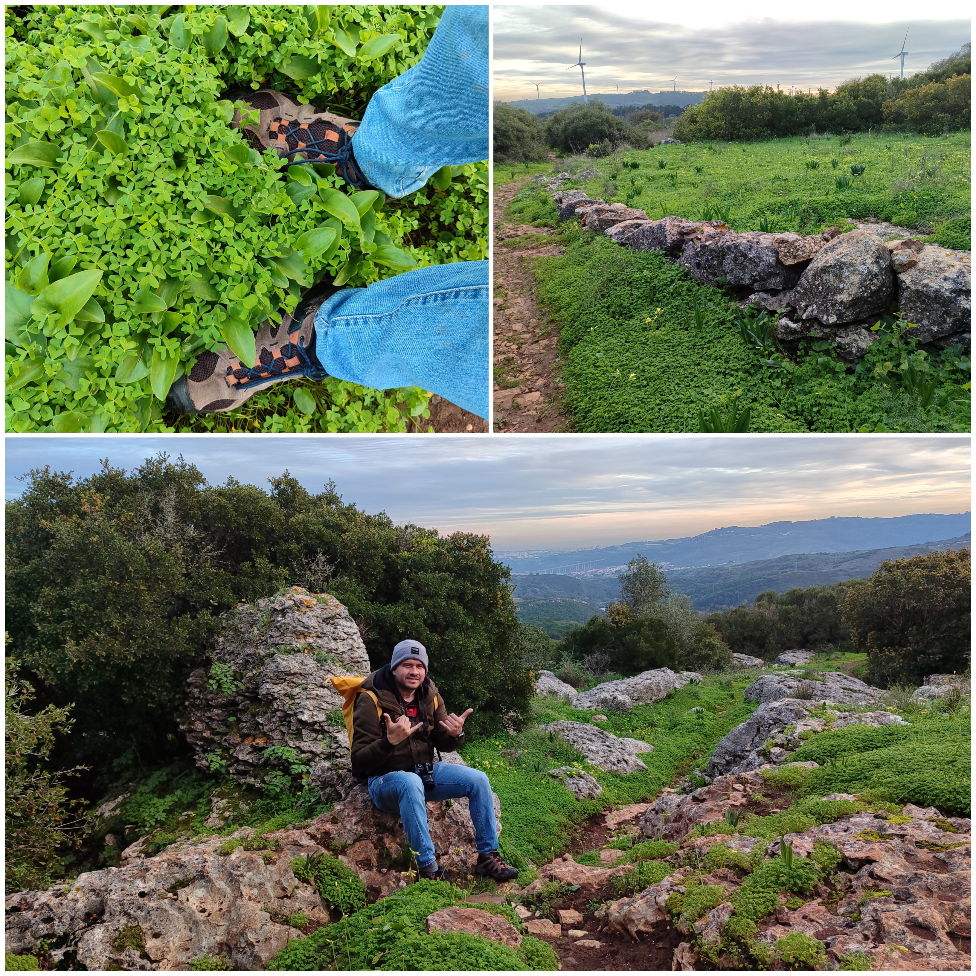
Clearly what I will tell you below is nothing more than a legend and you can look for it in the reviews of the place! Legend says that whoever made the path cursed it and that each person who completed it had to pay a tribute to nature, which always claims what is hers... Therefore, each person who makes the path leaves something on the ground. ranging from stone tombs to paths and accessories for the souls that rest here to have fun! And I tell you, I did the trail at dusk, almost at nightfall, and it is horribly hot in the area, with about 12 degrees, so that is mysterious and strange!🚙🌄🙇♂️
Claramente lo que te contare a continuacion no es mas que una leyenda y la puedes buscar en las reseñas del lugar! dice la leyenda que quien hizo el sendero lo maldijo y que cada persona que lo llegase a completar debia pagar un tributo a la naturaleza que reclama siempre lo que es de ella... Por tanto cada persona que hace el sendero deja algo en el suelo que va desde tumbas de piedras hasta caminos y accesorios para que se diviertan las almas que aqui descansa! y te digo hice el sendero en el atardecer casi al anocheser y es un calor horrible en la zona habiendo como 12 grados eso si que es misterioso y extraño!😨😳


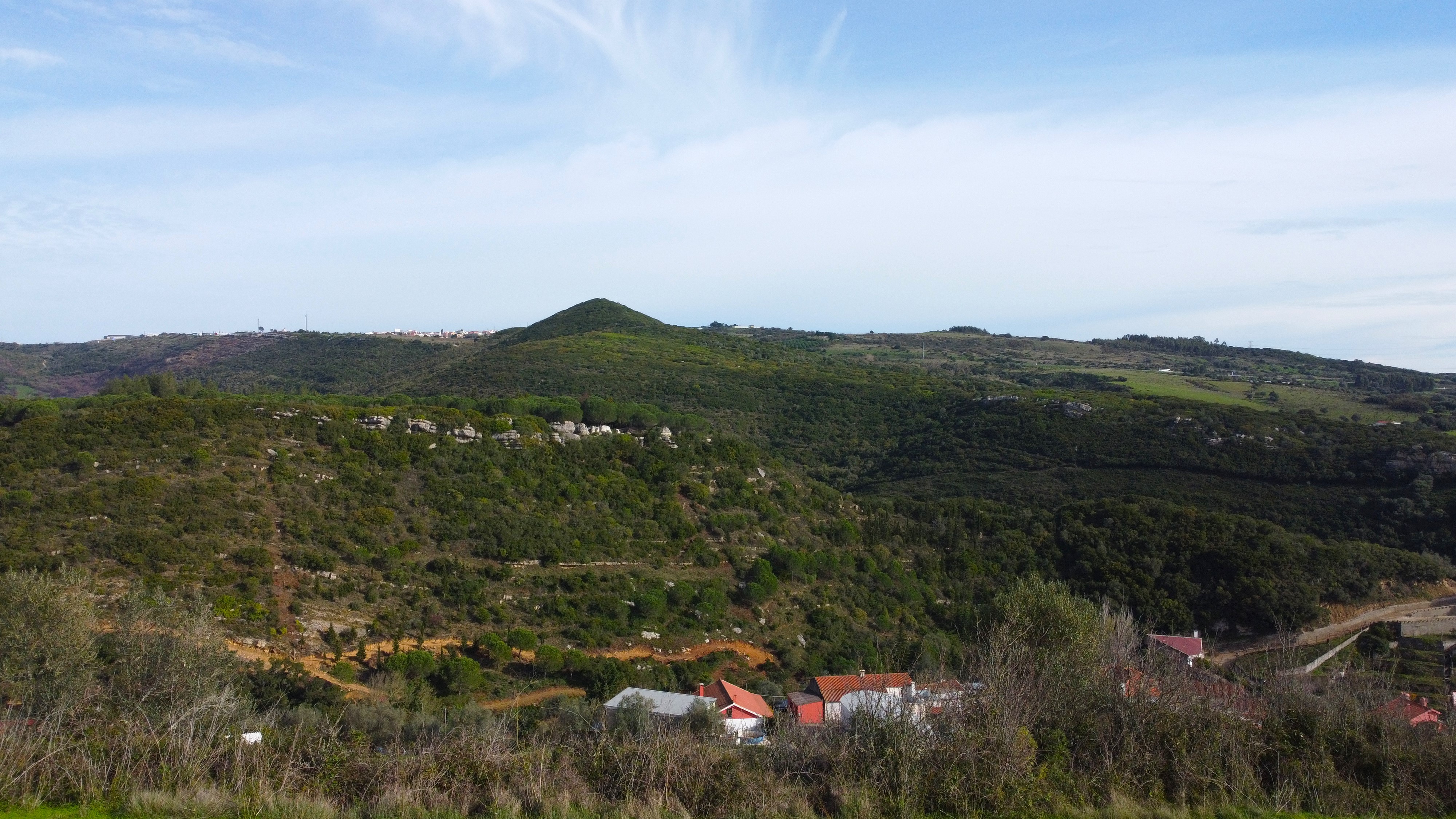
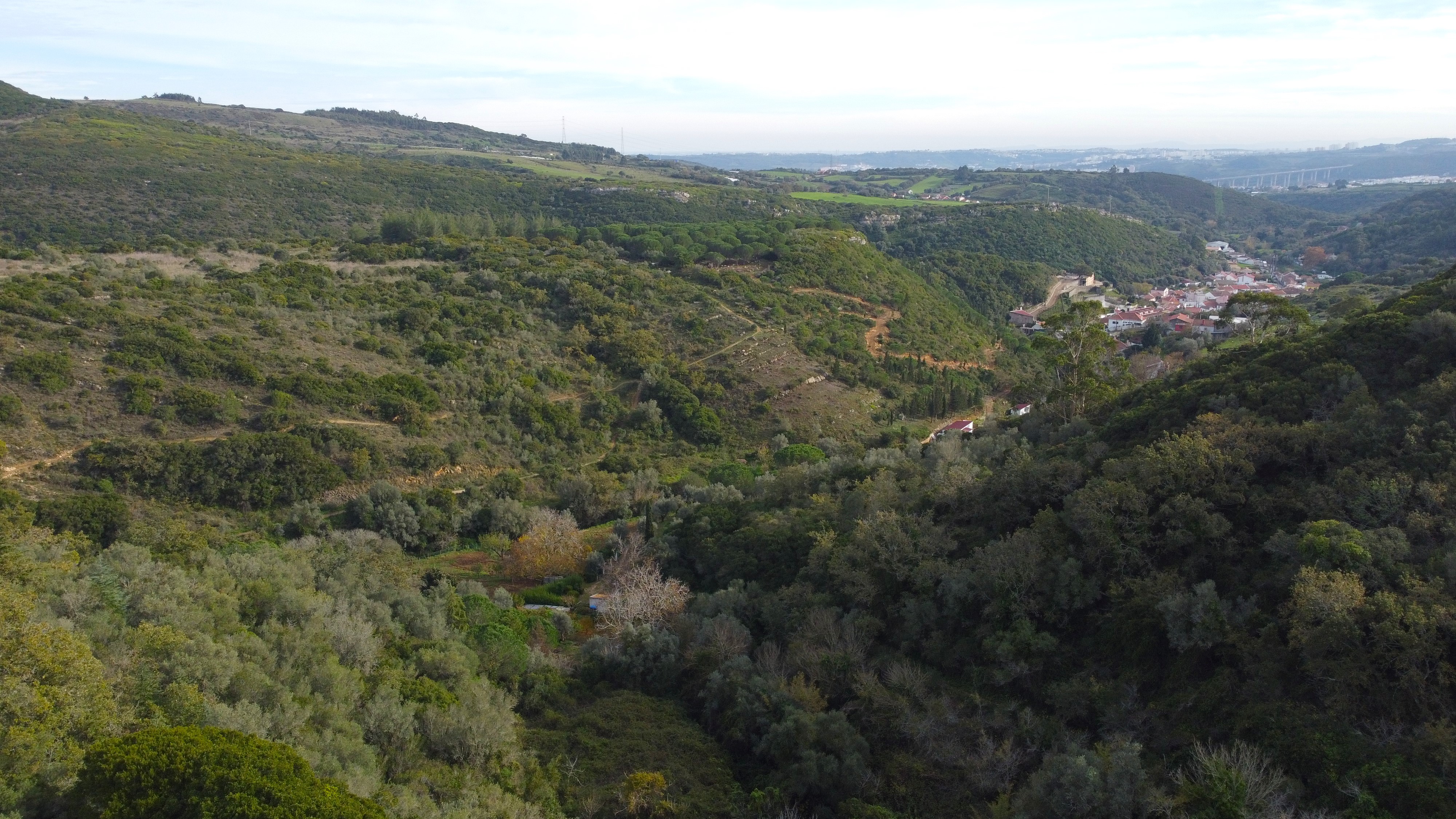
Leaving aside the mythical and mysterious, the path is short, I would say about 3km and it goes around that mountain that you saw in the drone, I am literally at the top at about 400 meters or so! The path is demanding and there are many unevenness as you skirt the mountain. I recommend that you always watch where you step because there are craters between the stones and be very careful when approaching the edge. These rocks fall apart easily. They are thousands of years old here!🌄🚩🧭
dejando aun lado lo mitico y misterioso el sendero es corto diria unos 3km y va alrededor de aquella montaña que vistes en el drone literalmente estoy en el top a unos 400 metros mas o menos! el camino es exigente y hay muchos desniveles como bordearas la montaña te recomiendo que siempre mires donde pisas porque hay crateres entre las piedras y mucho cuidado con acercarte al borde estas rocas se desprenden con facilidad tienen miles de años aqui!🙇♂️🚙🚵♂️🚶♀️


The landscape is extremely beautiful and humid, you are literally going to climb the mountain twice, being one of the paths more dangerous than others. According to what I read, there was also a Christian walk here where the entire village climbed the mountain to reach a small chapel in the top let's say like a procession something like that! I had to be quick because now the sun sets at 6 so I'm not allowed to fly the drone at night, however the weather favored me in all aspects and I liked the results of the shots!👀🧭🌏
El paisaje es extremadamente hermoso y humedo, literalmente vas a subir la montaña dos veces siendo uno de los caminos mas peligrosos que otros, segun lei tambien por aqui se hacia una caminata cristiana donde toda la aldea subia la montaña para llegar a una pequeña capilla en el tope digamos como una procesion algo asi! tuve que ser rapido porque ahora el sol se oculta a las 6 asi que no tengo permitido pilotear el drone en la noche sin embargo el clima me favorecio en todos los aspectos y me gusto el resultado de las tomas!🙇♂️🍍


I met several interesting places. I would like to describe them all but it would be several posts! So focusing on the trail, it was not easy to take aerial shots in some parts because I was afraid of hitting the drone with some weeds and falling into the void and there it was impossible to recover it, so in the most complicated areas I preferred to take photos with my camera! You can get here by car, I don't think public transportation is there! It is a very isolated place!🚙🙇♂️🧭
conoci varios lugares interesantes me gustaria describirlos todos pero serian varios post! asi que centrandonos en el sendero no fue facil hacer tomas aereas en algunas partes porque tenia miedo de golpear el drone con alguna maleza y caer al vacio y alli era imposible recuperarlo asi que en las zonas mas complicadas preferi tomar fotos con mi camara! puedes llegar aqui en carro, transporte publico creo que no llega! es un sitio muy aislado!🌾🌏🍄


After completing my entire adventure I am very happy because everything went well! Despite the many warnings from people who did not recommend doing the trail in winter because of the mud, it seemed super extreme to me. In reality, I slipped several times, but with hiking poles and boots it is almost impossible to fall, so if you come well prepared, do not Nothing happens and of course don't forget to bring your drone!🚩🌄😳
Luego de completar toda mi aventura me voy muy contento porque todo corrio bien! apesar de las muchas advertencias de personas que no recomendaron hacer el sendero en invierno por el barro a mi me parecio super extremo en realidad me resbale varias veces pero con los bastones de excursion y las botas es casi imposible caerte asi que si vienes bien preparado no pasa nada y claro no dejes de traer tu drone!🌏🚩🌄


DNA is an organization to foster and DENSIFY NATURE-APPRECIATION which aims to establish REPORTS OF BIODIVERSITY DATA that is contributed by all of us Hiveans and subsequently cataloged.
Therefore DNA searches for HIGH-QUALITY posts that aim to DESCRIBE and determine the BIODIVERSITY AROUND YOU with added EXPLANATIONS and INFORMATION. For these informative posts they offer a CURATION SERVICE using the @dna.org account. It is also a CURATION TRAIL. Just add the #dna TAG if you think that any of your posts is what they are looking for.
THANKS FOR READING ME (PHOTOS AND VIDEO OF MY PROPERTY) / GRACIAS POR LEERME FOTOS Y VIDEO DE MI PROPIEDAD🙂🧠🦾👍
Show more
Tags :
Woo!
This creator can upvote comments using 3speak's stake today because they are a top performing creator!
Leave a quality comment relating to their content and you could receive an upvote
worth at least a dollar.
Their limit for today is $0!
Their limit for today is $0!

4 views
6 months ago
$
7 views
a year ago
$

6 views
5 months ago
$
3 views
3 months ago
$
4 views
10 months ago
$
More Videos

9 views
a year ago
$

7 views
a year ago
$

23 views
a year ago
$

5 views
2 years ago
$

12 views
3 weeks ago
$

0 views
2 years ago
$

0 views
2 years ago
$

4 views
2 years ago
$

3 views
2 years ago
$

5 views
2 years ago
$
31 views
a year ago
$

11 views
a year ago
$
5 views
2 years ago
$
11 views
2 years ago
$

4 views
a year ago
$

23 views
4 months ago
$

98 views
3 years ago
$
15 views
a year ago
$

1 views
2 years ago
$

0 views
3 years ago
$

5 views
a year ago
$
2 views
7 months ago
$
16 views
a year ago
$
1 views
2 years ago
$
Comments:
Reply:
To comment on this video please connect a HIVE account to your profile: Connect HIVE Account