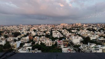
The Use Of Drones For Aerial Photography
10
About :
Photogrammetry is the art, science, and technology of information acquisition about physical objects and the environment through the process of recording, measuring, and interpreting aerial photographs (Thomson and Gruner, 1980). Source
Previously aerial photo mapping was very expensive due to the process of recording photos using airplanes, helicopters, hot air balloons and using cameras that were quite large as the times evolved and the huge cost of technology could be overcome by switching to using drone technology / UAV aerial mapping is increasingly because it provides the latest and complete information, according to user needs.
Stages in doing aerial photo mapping
- Make a flight plan
- Make a Ground Control Point (GCP) plan
Types of photos
- Vertical Photo is the axis of the camera when shooting is done completely vertical or slightly tilted no more than 3 °
- Low oblique photo The photo axis experiences a slope between 3 ° and 45 ° and there is no visible horizon line
- The hight oblique photo axis of the photo experiences a slope between 45 ° and 90 ° and a horizon line is visible
In the process of recording oblique photo images often occur due to several factors
- Plane motion that is too fast
- A wind push from under or on a plane
- Relief changes in tall buildings
The scale of the photo is compared to the distance of two objects in the photo with the actual distance above the ground. The difference, on a map, the scale will be the same at each point because the map is an orthogonal projection of an appearance on the ground surface. Conversely, an aerial photograph is the result of a central projection which results in a scale varying according to the height of the point concerning a particular reference plane. Source
Pixels are the smallest parts of a digital image. Monitors display images by dividing the screen into thousands (even millions) of pixels, arranged in many rows and columns. These pixels are so close to one another that they look like they are connected. Source
basically the smaller the size of a pixel, the smoother the resulting image
Show more
Tags :
Woo!
This creator can upvote comments using 3speak's stake today because they are a top performing creator!
Leave a quality comment relating to their content and you could receive an upvote
worth at least a dollar.
Their limit for today is $0!
Their limit for today is $0!
purnamaeko has no more videos yet.
More Videos

1 views
3 years ago
$

12 views
5 months ago
$

0 views
2 years ago
$

0 views
a year ago
$

1 views
a year ago
$
4 views
2 years ago
$
12 views
a year ago
$

10 views
a year ago
$

3 views
8 months ago
$
6 views
a year ago
$
1 views
2 years ago
$
4 views
a year ago
$

6 views
a year ago
$

17 views
11 months ago
$
7 views
3 years ago
$
1 views
3 years ago
$

15 views
a year ago
$
7 views
7 months ago
$
3 views
2 years ago
$

Vibes Web3 Music Competition Week 6 - Dos Oruguitas - Encantados / Sebastían Yatra. Cover @artmedina
9 views
a month ago
$
2 views
8 months ago
$

0 views
5 months ago
$
1 views
4 years ago
$

23 views
2 years ago
$
Comments:
Reply:
To comment on this video please connect a HIVE account to your profile: Connect HIVE Account